Showing posts with label Barnes Assembly A. Show all posts

Monday, June 6, 2011

Gates Wide Open on June 6, 2011

Barnes Assembly A and West Carpo on 
Matthew Road (Chesapeake)
A secured entrance gate shall be required. All gates are to be kept locked when the operator or his employees are not within the pad site boundary enclosure. (Grand Prairie, TX Gas Drilling Ordinance,  Section 13-516, Page 54)**
**Link to GP Gas Drilling Ordinance, Scroll down to Page 54.

Thursday, February 3, 2011

New Barnes Assembly A Wells 1H, 2H and 4H (Just Permitted 1/31/11 by the RRC) for Chesapeake

The new ones are kinda short. This may explain some of that.


The longer one you see is API# 113-30193 (3H) ~ 
The one under Rule 37 Consideration right now ~
Meaning: If you won't sign a lease, Chesapeake will just have the Railroad Commission conduct a Hearing at their (Chesapeake's) pleasure and make you travel to Austin on your own dime dollar and then most likely they'll just take your minerals, anyway, and FORCE you into the Pooled Unit with your neighbors and especially the large land owners. Large land owners who really need you so they can make most of the royalties, if any, for the Lease. Nice, huh?


Those pentagon (5-sided) shapes you see are apparently two (maybe three) Pad Sites Leaseholds converging at 4351 Matthew Road with currently 5 different wells permitted and/or drilled from potentially 4 separate leaseholds (that we know of) including...Barnes Assembly A, West Carpo, East Carpo and 2 "Future Wells."  There will be up to 11 wells drilled (at this time) from this location according to the Detail Map Below.  


Notice the Gas Gathering Pipeline (in green) that will get the gas out of there. What was once a beautiful and tranquil cow pasture is clearly now an industrial zone.


Oh, and there's Fish Creek, too ~ see it in bright BLUE on the Map.  A well-known old creek in southern Grand Prairie that runs right above all the drilling and horizontal, hydraulic fracturing that will be going on in that area in the immediate future.


And the latest  "Detail" of this area as currently shown on Railroad Commission Maps for these permits. (This seems to have changed over a short time.  Not sure what happened to Barnes Assembly B that used to show up. Maybe it sounded too much like Barnes Assembly A or maybe it's been put on the Chesapeake shelf for now.)

Ah, Chesapeake

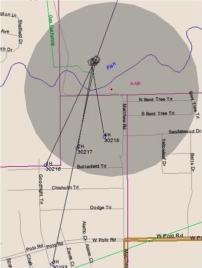
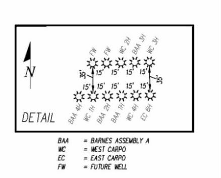
3 More Wells for the Barnes Assembly A Pad Site Leasehold (4351 Matthew Road) were approved Monday for Chesapeake by our almost-defunct Texas Railroad Commission.  


Very interesting that these horizontal wells seem to be shorter in length than our well-known API #113-30193, which dips very deep into Trailwood.  Maybe they're more like shots-in-the-dark...or rather like a lot of Rule 37 "Waiver" Notifications arriving in the mail very soon for our Trailwood neighbors. Stealing property and/or paying very little for it seems to be all the rage.  


New Barnes Assembly A Permits ~ API #113-30216, #113-30217 and #113-30218.


By the way, we simply love going to Austin, taking off work, jeopardizing our lives in snow and ice (like 8 of us did Tuesday, February 1, 2011) for the API# 113-30193 Rule 37 "Waiver/Exception" Hearing.


QUESTION:  Since all the activity related to the Barnett Shale is in the BARNETT SHALE,  why are all the citizens affected by Rule 37 Waivers required to travel to Austin to DEFEND their property rights??


Somebody really needs to answer that question in the TEXAS Legislature.