We have just discovered something crazy. So, you may ask, what else is new??
The Background: 2010
Chesapeake's Corn Valley Pad Site was administratively permitted by the City of Grand Prairie in the summer of 2010 with very little fanfare ~ even though it was clearly within the 3,000 foot Zone of Exclusion ~ as defined by the United States Army Corps of Engineers (USACE) ~ with their 1996 publication: Texas Resource Management Plan and Record of Decision. This publication defines the Rules going forward for oil and gas drilling activity near the dams and lakes under United States Army Corps of Engineers' jurisdiction.
Two Years Earlier: 2008
On July 15, 2008, Shale gas operator XTO said the following to Grand Prairie, TX City Council (during a Public Hearing about XTO's Lynn Unit):
"...The Corps of Engineers is aware of this activity based on an agreement with the Bureau of Land Management on this property."
~ Walter Dueease, XTO, July 15, 2008
So, as it turns out, the Bureau of Land Management (BLM) is actually a "Lessor" of XTO's Lynn Unit (located just to the west of the Corn Valley Pad Site and to the northwest of the Joe Pool Lake Dam) ~ with 43+acres of land! The statement in the Minutes of this meeting (Pages 8-10) did not make that fact clear at all.
Unfortunately, this information had escaped us until now. (A City without a Specific Use Permit for gas drilling is a City headed to Shale Gas He**...) But let us not digress...
The United States of America owns land within the Lynn Unit and signed a mineral lease with XTO sometime in 2007 or early 2008. Three wells appear to be completed and/or in production at this time. A total of 7 have been permitted as far as we can tell.
The Deal
Here's the deal. The Bureau of Land Management violated its own Rules when it leased those 43+ acres for shale gas drilling.
It all got rolling when the Grand Prairie, TX City Council approved the setback variance for the Lynn Unit during that July 15, 2008 Public Hearing after Walter Dueease with XTO assured the Council that all was well (Link to the July 15, 2008 GP City Council Meeting, Pages 8-10).
Apparently, neither any Bureau of Land Management personnel or US Army Corps of Engineer personnel were present or spoke during that City Council Public Hearing. The City Council Minutes reflect only that Mr. Dueease told the Council that USACE was aware of this pad site since the BLM had land there...but there was never any discussion or mention of the Exclusion Zone or that the BLM was a "lessor," for this Unit.
And now, because of those actions, thousands of people's lives are in peril if there were to be a catastrophic failure of the Joe Pool Lake Dam. Thank you, Commander Muraski of the Fort Worth District of USACE, for your warning.
Our country needs to get its sh** together.
Texas Railroad Commission GIS Map of the area near XTO's Lynn Unit.
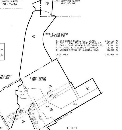
The Lynn Unit Plat
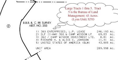
(Above) The Lynn Unit Plat (showing the 5 largest lessors).
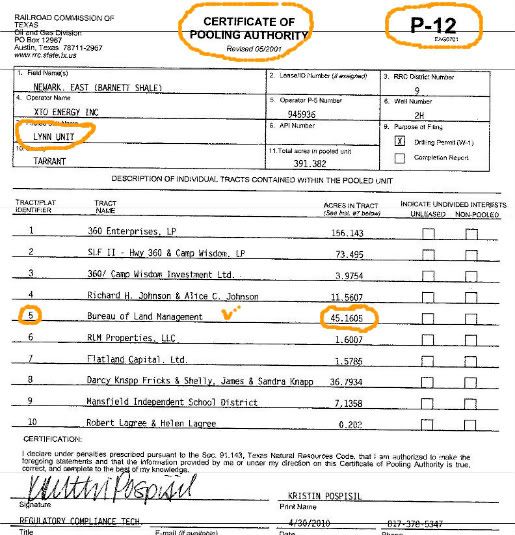
The Industry Standard P-12 Certificate of Pooling Authority (provides the list of lessors in the "pooled" unit).
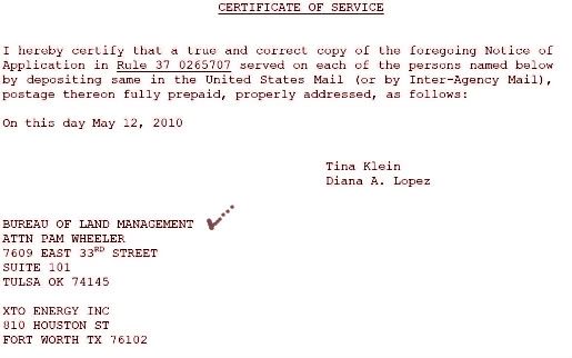
(Above) A Service List for a Rule 37 (used when property owners have not signed a lease and the industry needs them)...that's
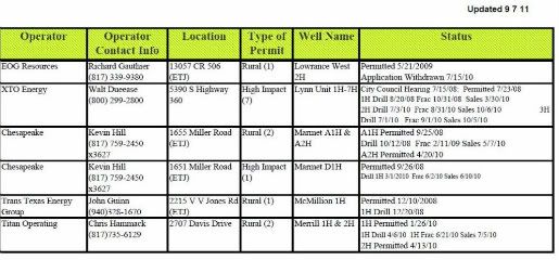
(Above) The Grand Prairie, TX Shale Gas Drilling Status Report for September 7, 2011. It shows all activity from the beginning for every well including city permit dates, drilling dates, fracking dates and dates for sales from specific sites.
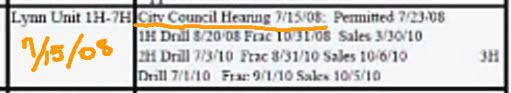
Larger view of the Grand Prairie, TX Shale Gas Status Report (above) showing July 15, 2008 as the date that the Lynn Unit was voted on by City Council. It also shows that Wells 1H, 2H and 3H are "completed" and were, at one time, "in production."
So, why did the BLM violate its own rules? Can we possibly say this?
"The BLM looks at it more as a business-driven process," Otto said. "It's not like I have Vice President Cheney calling me up and saying you need to get this done. But there definitely is that unspoken pressure…mostly from the companies, to develop their resources as they'd like to see fit…to get things done and get them done pretty fast." [emphasis added.]
Also, as of March 17, 2011, there's a new document. We're just not clear why this was necessary, since they "reference" the 1996 document right there on Page 1:
We told ya this was crazy.
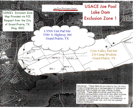
**IMPORTANT UPDATE**: Below is the United States Army Corps of Engineers (USACE) Map depicting the Exclusion Zone. This map and additional documents were provided to the City of Grand Prairie, TX during meetings with USACE in early 2011. Documents were received on August 3, 2011 via FOI Request by the Westchester-Grand Prairie Community Alliance and were important to this report.
Important Note: Color Emphasis and Labels were added to this Black and White Map for clarity.
Link to Further Information about Exclusion Zone 2 ~ Another XTO Site and A New Blog Post on the Westchester Gasette
No comments:
Post a Comment